From Geology to Water: Building QazaqSu Atlas
How studying geology shaped an interactive water atlas for Kazakhstan, bringing rivers, dams, wetlands and flood information together in one platform.
From Geology to Water: Building QazaqSu Atlas
I first came across this idea while scrolling LinkedIn. Shagbaor Hycent Amool had shared the Nigeria Water Resources Atlas, an interactive map bringing rivers, dams, wetlands and flood information together. I paused and wondered: what could a similar atlas look like for Kazakhstan, shaped around its own landscapes and water systems?
I studied Geology and Exploration of Mineral Deposits, so the idea felt close to the way I already think about landscapes. Geology taught me to look beneath the surface, trace how land was formed and ask how terrain influences the movement of water.
Kazakhstan is a country of striking contrasts. The northern steppe gives way to drier central plains and deserts. In the east and southeast, the Altai and Tian Shan rise above the surrounding land. Its geological story is just as varied, with ancient rocks and uplands across regions such as Saryarka, the Altai and the Tian Shan. Kazakhstan’s landscape assessment describes these geological and landscape features.
These differences matter for water. Rivers, lakes and reservoirs connect mountain catchments to dry plains, cities, farms and ecosystems. They also connect countries. Kazakhstan’s government estimates average annual surface-water resources at about 106 cubic kilometres, with 44.3% arriving through transboundary rivers. The 2024 government overview makes clear how important those shared flows are to the country’s water future.
That scale can be difficult to see when information is spread across maps, reports and separate websites. I wanted to make it easier to explore the connections.
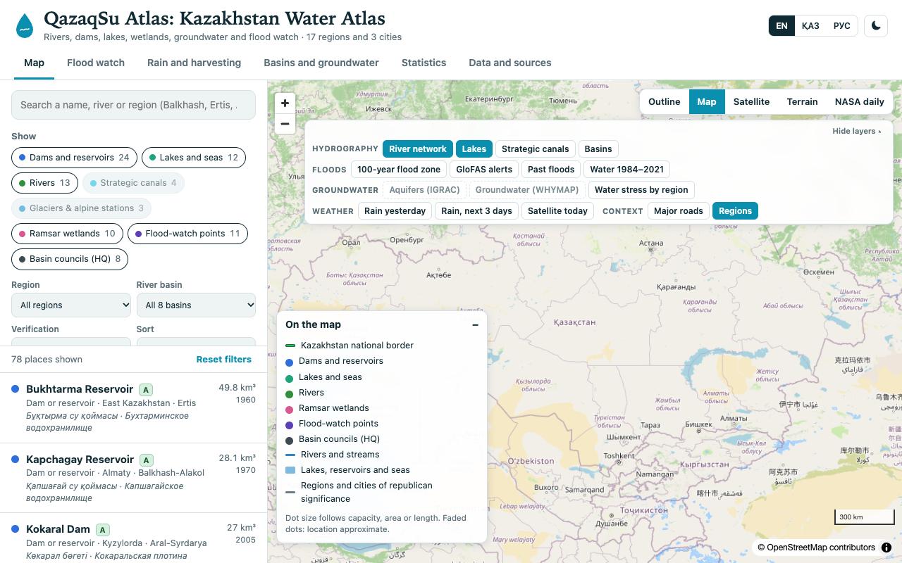
The result so far is QazaqSu Atlas, a multilingual interactive map of Kazakhstan’s water resources. It brings together key dams and reservoirs, rivers, lakes, Ramsar wetlands and flood-watch points. People can search and filter places by region or basin, inspect available details and sources, and explore the map in English, Kazakh or Russian.
The atlas also has layers for river basins, canals, flood information, rainfall, satellite imagery and the historical surface-water record from 1984 to 2021. Each mapped place has a verification grade to help show how well supported its information is.
I’m treating this as a work in progress and trying to make the data’s limits clear. For example, the flood-flow information comes from a model, not direct readings from official river gauges. The water-stress layer still needs verified values. Being transparent about those gaps is part of making the atlas useful.
Next, I’d like to connect more official monitoring data, strengthen the groundwater and water-quality information, and add reliable measures of regional water stress. I’m also interested in linking geology and terrain data with river basins and groundwater, where good sources are available. These additions could help people explore not only where water is, but how it moves through the landscape and who depends on it.
Water is experienced locally, at a riverbank, a reservoir, a farm or a city tap. Its story often stretches much farther. My hope is that QazaqSu Atlas can help students, researchers, planners and curious readers see more of those connections.
If you work with Kazakhstan’s water data, have a correction, or know of a useful source, I’d be glad to hear from you.
Explore the live interactive atlas at qazaqsu.nelsonizah.com, or explore the QazaqSu Atlas project on GitHub.

Written by
Nelson Izah
I write about geology, software engineering, and the spaces where they intersect. When I'm not writing or building, you can find me exploring the outdoors or reading a good book.
How studying geology shaped an interactive water atlas for Kazakhstan, bringing rivers, dams, wetlands and flood information together in one platform.
Enjoyed this piece?
Leave a reaction to let the author know what resonated with you.
Related Posts
The $250,000 Question Every Exploration Company Faces
There’s a number that sits behind almost every decision in mineral exploration: $250,000. That’s roughly what a single 500 meter diamond drill hole can cost. How GeoMiner compresses months of regional satellite reconnaissance into hours.
Share Your Thoughts
What resonated with you? I'd love to hear your perspective.