
SlopeWatch KZ: Kazakhstan Landslide & Geohazard Atlas
Problem
Kazakhstan’s southeastern and eastern mountain cordilleras—notably the Northern Tien Shan, Dzungarian Alatau, and Altai ranges—are among the most geodynamically active and hazard-prone terrains in Central Asia. Catastrophic historical precedents like the 1887 Verny (M7.3), 1889 Chilik (M8.3), and 1911 Kemin (M8.0) earthquakes triggered monumental rock avalanches, valley damming (forming Lake Kaindy), and deadly mudflows (such as the 1921 Almaty and 1963 Lake Issyk outbursts). Yet critical landslide and mudflow data has historically remained confined to academic paywalls, regional qualitative maps, or legacy paper archives, leaving mountain communities and infrastructure vulnerable to cascading climate and seismic threats.
Approach
🌐 Real-Time 3D Terrain & Slope Geometry
- GPU-Accelerated Digital Elevation Model (DEM): Decodes RGB Terrarium elevation tiles directly in WebGL, generating continuous 3D topography, real-time hillshading, and dynamic contour lines.
- Sun Azimuth & Solar Illumination Controls: Allows geologists to manipulate solar angle (0°–360°) to reveal subtle fault scarps and structural slope fractures through custom shadow casting.
- Automated 3D Drone Flyovers: Simulates smooth low-altitude aerial reconnaissance flights along defined landslide paths and gorge profiles.
🌧️ Live Rainfall & Weather Trigger Telemetry
- Integrates directly with the Open-Meteo API to calculate 3-day and 7-day antecedent rainfall accumulation and 3-day forward precipitation forecasts across high-risk mountain sectors.
- Snowmelt Acceleration Flags: Detects rapid warming anomalies following recent snowfall—a primary precursor to catastrophic mudflows.
🌋 Live Earthquake Feeds & Active Tectonic Faults
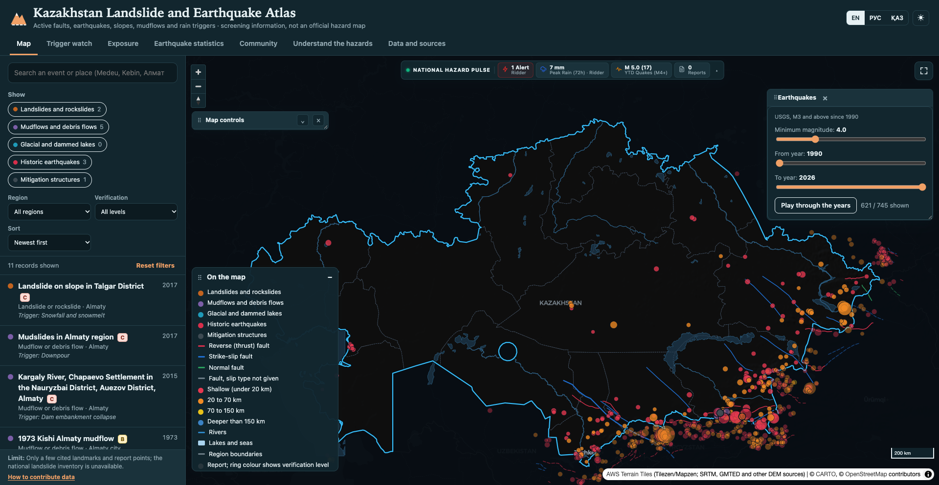
- Streams live seismic activity (M ≥ 3.0 from 1990 to present) directly from the USGS ComCat API, filtered dynamically across Kazakhstan and its transboundary margin.
- Overlays active fault lines and fold systems from the GEM Global Active Faults Database, helping users correlate recent tremors with mapped regional fracture zones.
📈 Interactive Topographic Cross-Section Profiler
- Users can click any traverse line across a valley or ridge to instantly compute an elevation profile chart showing cumulative distance, slope gradient, peak/trough elevations, and active fault crossings.
🛰️ National Hazard Telemetry Ribbon & Citizen Reporting
- Persistent header telemetry ribbon providing live national risk status across active alerts, 24h rainfall triggers, recent seismic events, and verified citizen reports with Level A/B/C confidence ratings.
- Tri-lingual accessibility in Kazakh (Қазақша), Russian (Русский), and English (EN).
Tech Stack
Results
Delivers an open-access 3D geohazard observatory and early-screening atlas for Kazakhstan with 100% serverless edge delivery on Cloudflare Pages. Unites high-resolution satellite terrain, active tectonic fault models, real-time meteorological precipitation thresholds, live USGS earthquake telemetry, and community field reporting into an authentic scientific cartography platform.
What I Learned
Engineered custom GPU-accelerated client-side raster DEM elevation sampling and tile protocols (slope:// and susc://) with MapLibre GL; synthesized real-time multi-hazard telemetry by coupling asynchronous USGS seismic feeds with Open-Meteo antecedent precipitation models directly in the browser.
Enjoyed this piece?
Leave a reaction to let the author know what resonated with you.